| Cottage Woods
is near Hicks Landing, a private and well run boat launching facility.
It is possible
to pay on per use basis, or purchase a one year pass.
All this is
just a few minutes from Cottage Woods.

The Rappahannock is a tidal body of
water leading to the Chesapeake Bay and thence the Atlantic Ocean.
Sailing ships once visited the wharfs along the river in colonial times,
connecting the populations with Europe. Later, the steamships
became the favored means of transportation to the hub at Baltimore,
Maryland.
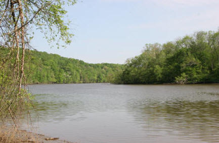
Above, the Rappahannock, Spring, 2008 
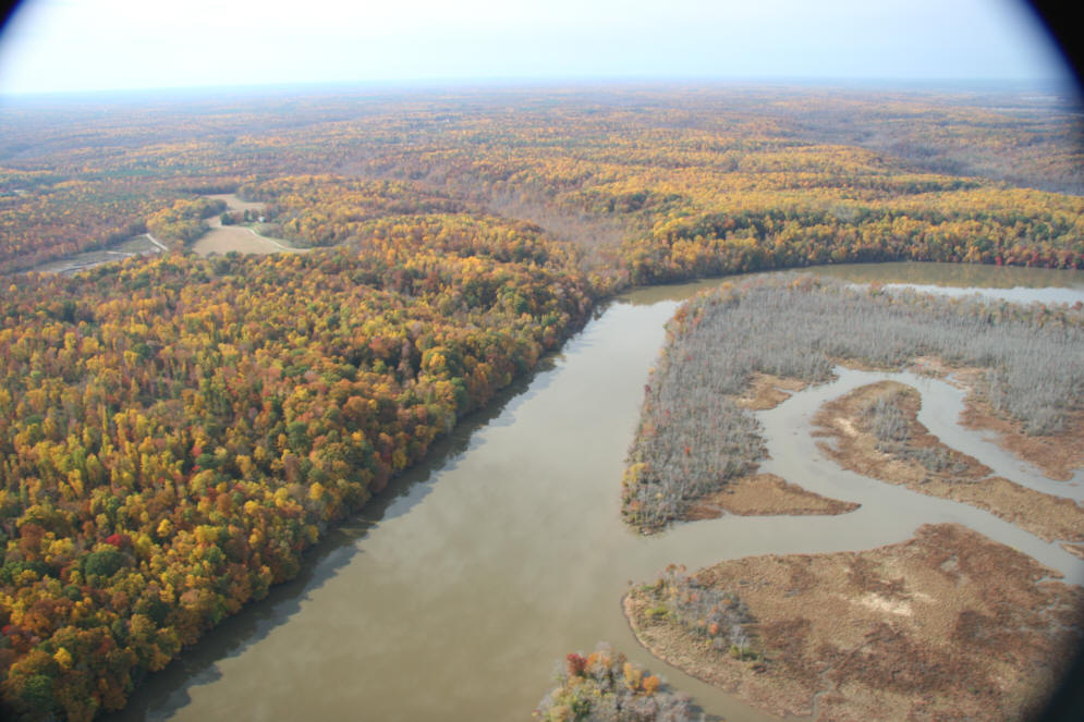
Above, and below, double click to view Aerial looking up and across the river towards Rock
Stop, the fields are visible.
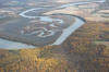
View of Cleve Marsh, across from Rock Stop. Rock
Stop occupies the high bank of the river, with marsh dominating the
other shore.
Tidal River Largemouth Bass Outlook - 2008 -
Rappahannock
Largemouth population has experienced good recruitment
over the past four years – including an exceptionally strong 2005
year-class (Figure 4). This combined with relatively low adult
mortality, should yield increased angler catch rates and continued
improvement in the size structure of the catch. However, electro-fishing
catch rates for largemouth bass in the tidal Rappahannock River continue
to be among the lowest of any tidal river in Virginia, with catch of
largemouth over 15 inches about half that of the James River system. In
electro-fishing surveys, the highest bass catch rates continue to be
from Hicks Landing downstream to near Port Royal. Below Portobago Bay,
only limited areas of suitable habitat and forage are available –
primarily shorelines adjacent to side-channel drop-offs and marsh back
channels. However, recent electro-fishing surveys indicate good numbers
of preferred size largemouth can be found in these isolated pockets, as
well as in certain tidal tributaries.
SOURCE:
http://www.dgif.virginia.gov/fishing/waterbodies/reports/2008%20Tidal%20River%20Largemouth%20Bass%20Outlook.pdf
Retrieved March 31, 2008.

|
Rock Stop Farm
Circa 1791
Rappahannock Academy,
Virginia
The Rappahannock River

Above, double click to view or print a
section from the 1856 river chart.
Note "Moons Mount" and the dots, which
represent buildings. Down river from Moons Mount, so named because
it is a very high hill, is a creek, which is the same creek traversing
Rock Stop. The current U.S. Geological Topographic Map shows that
creek area, down from Moons Mount, as "Moon's Mount Wharf" (please go to
the icon "Land" on the sub-menu, for that map).

Above, and below, double click to view Aerial looking up and across the river towards Rock
Stop, the fields are visible.
View of Cleve Marsh, across from Rock Stop. Rock
Stop occupies the high bank of the river, with marsh dominating the
other shore.
Tidal River Largemouth Bass Outlook - 2008 -
Rappahannock
Largemouth population has experienced good recruitment
over the past four years – including an exceptionally strong 2005
year-class (Figure 4). This combined with relatively low adult
mortality, should yield increased angler catch rates and continued
improvement in the size structure of the catch. However, electro-fishing
catch rates for largemouth bass in the tidal Rappahannock River continue
to be among the lowest of any tidal river in Virginia, with catch of
largemouth over 15 inches about half that of the James River system. In
electro-fishing surveys, the highest bass catch rates continue to be
from Hicks Landing downstream to near Port Royal. Below Portobago Bay,
only limited areas of suitable habitat and forage are available –
primarily shorelines adjacent to side-channel drop-offs and marsh back
channels. However, recent electro-fishing surveys indicate good numbers
of preferred size largemouth can be found in these isolated pockets, as
well as in certain tidal tributaries.
SOURCE:
http://www.dgif.virginia.gov/fishing/waterbodies/reports/2008%20Tidal%20River%20Largemouth%20Bass%20Outlook.pdf
Retrieved March 31, 2008.
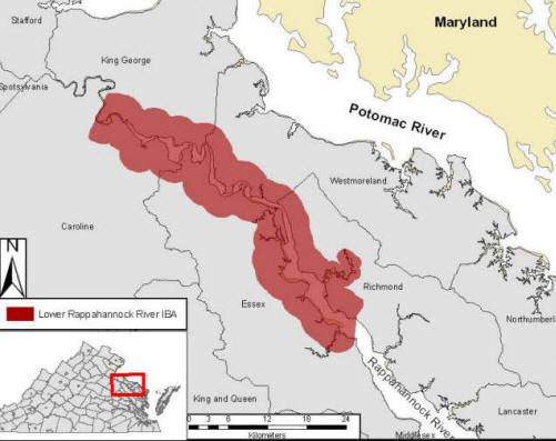
Site Description From:

Compared to all other major tributaries of the
Chesapeake Bay, the reach of the Rappahannock River between Tappahannock
and Port Royal remains the most pristine [the same can be said for the
area around Rock Stop on the river]. The waterway supports
extensive forested wetlands and pristine shorelines embedded within a
predominantly rural landscape. Uplands have a wide range of topographic
features that result in a high diversity of habitats within a relatively
small area. These areas are used for agriculture, forestry, and a
growing ornamental nursery industry. Several large farms and historic
plantations remain intact. In recent years, the U.S. Fish and Wildlife
Service has made the area a focus for acquisition. Surrounding uplands
are composed of rural farmlands that support some of the largest
grassland bird populations in the Coastal Plain.
Conservation and Management Units
A growing and important portion of the IBA is owned and
managed for conservation purposes. In recent years the area has become
an acquisition target for both the U.S. Fish and Wildlife Service
and The Nature Conservancy. The relatively new Rappahannock River Valley
National Wildlife Refuge has been very successful in protecting
strategically important tracts within the area. The Virginia Department
of Game and Inland Fisheries manages Lands End Wildlife Management
Area for wintering waterfowl. In addition, many private landowners are
progressive in managing their lands for conservation benefit.
Birds
This reach of the Rappahannock River supports the only
known breeding population of Coastal Plain Swamp Sparrows in Virginia.
The status and geographic extent of this population remains unknown. The
area supports the densest breeding population of Bald Eagles in Virginia
and one of the largest summer and winter eagle concentration areas in
eastern North America with migrant eagle populations numbering in the
hundreds. The waterway is a significant area for waterfowl during the
winter months. Forested wetlands support breeding Neotropical migrants
such as the Prothonotary Warbler and Yellow-throated Vireo and large
winter roosts of blackbirds including the Rusty Blackbird. Surrounding
fallow open lands support one of the largest grassland bird communities
within coastal Virginia.
Conservation and Threats
Four primary threats are currently of concern including
1) conversion of open land to residential, 2) expansion of recreational
boating access to sensitive portions of the river, 3) contaminants
within the fishery used by piscivorous birds, and 4) continued expansion
of phragmites into sensitive marsh habitats. The urban centers of
Fredericksburg and Tappahannock are expanding and expected to place
pressure on the rural lands within this area in the future. Waterfront
property is particularly vulnerable to future development. Since many of
the species that depend on this area are sensitive to development,
further development remains a concern. The reach of the river between
Tappahannock and Port Royal supports one of the largest winter and
summer concentrations of migrant Bald Eagles in eastern North America.
These birds have been shown to be very sensitive to boating activity.
Increases in boating activity and the number of boat access points
within this stretch of the river will negatively impact migrant eagles.
In addition, because of their position at the top of the food web,
eagles will always be vulnerable to new contaminants entering the
system. Pristine marsh habitats and the sensitive species that depend
upon it are being threatened by dispersal of the invasive plant
phragmites from the large source population on Hoskins Creek. Expansion
of this population could seriously impact the integrity of this system
to support marsh bird communities.
SOURCE: http://www.audubon.org/bird/iba/virginia/Documents/Lower%20Rappahannock%20River.pdf
(BOTH above and below) Retrieved March 31, 2008.
Lower Rappahannock River IBA
For more information about this and other IBAs in
Virginia please visit our website at:
http://www.audubon.org/bird/iba/virginia/
Or contact Aimee Weldon, the Virginia IBA Coordinator,
at:
aweldon@audubon.org
or 804-788-7660
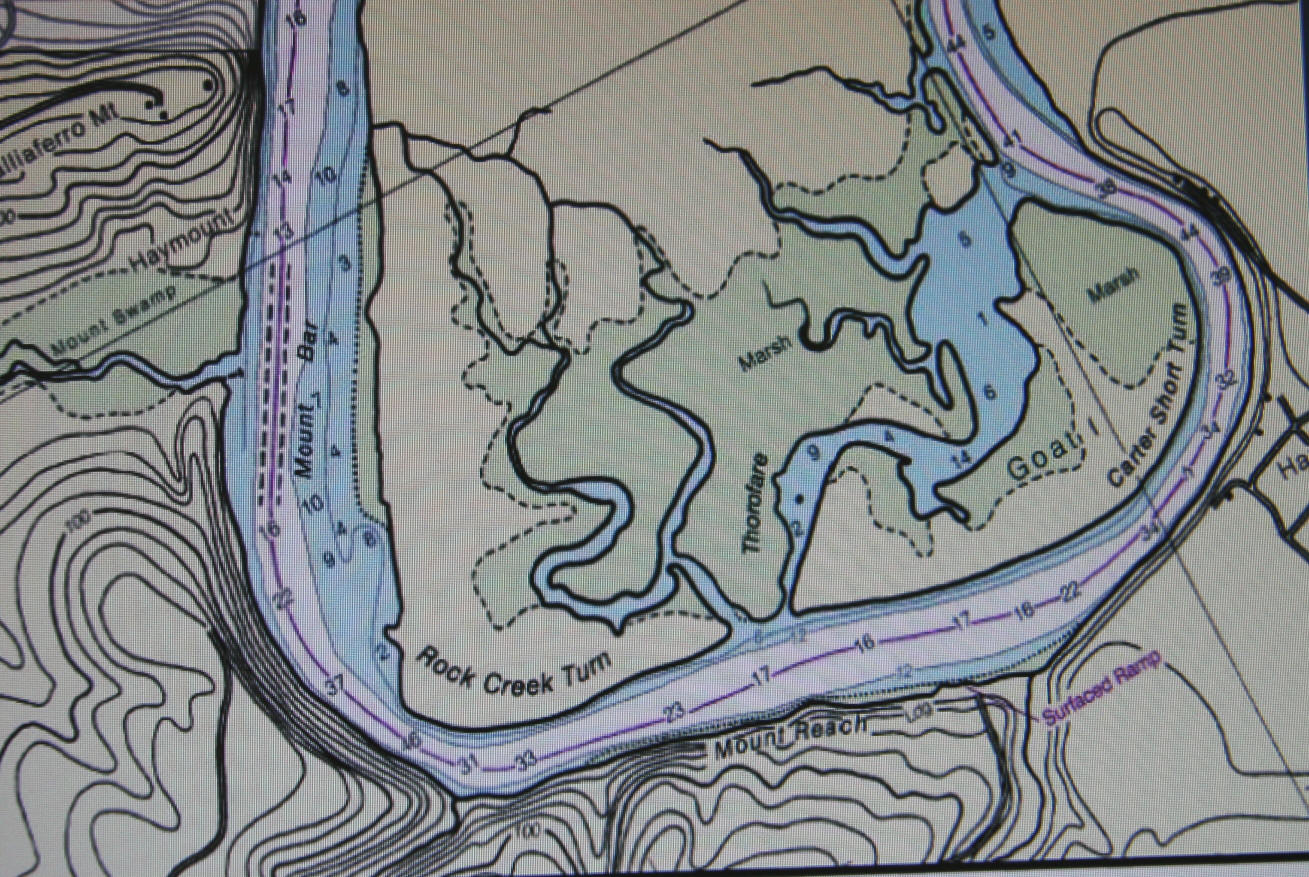
 Rock Stop is at the very bend in the river, across from "Rock Creek
Turn".
Rock Stop is at the very bend in the river, across from "Rock Creek
Turn". SOURCE:
http://www.oceangrafix.com/o.g/Charts/Atlantic/NOAA-Nautical-Chart-Rappahannock-River-Corrotoman-RiverFredericksburg.html
Retrieved March 31, 2008 |
|
|